 |
| Source: National Geographic |
On August 25, 2016, the National Park Service (NPS) turns 100. After a century of shepherding America's splendor, the Park Service and its personnel will rightfully be feted as dedicated, humble stewards of our country's most precious landscapes.
Personally, we have been lucky enough to visit many of the nation's 59 parks on all points of the compass. Each site has never failed to live up to its consecration as a place of American rarity, pride, and beauty. From the unspoiled trails to the popular overlooks, every curated destination within the wilderness is a testament to the work and vision of the Parks Service.
 |
| Source: National Park Service |
This august anniversary introduces many opportunities to weave the Parks into authentic classroom lessons. For example, the "Every Kid In A Park" initiative seeks to connect our nation's youth to its most treasured spaces. Additionally, a wide range of visualizations now provide easy ways to incorporate the centennial into state standards and skill-based curricula. At their least, these videos and graphics offer terrific kick-offs to a morning's discussion. At their best, these charts and illustrations support critical student proficiencies. They also bring to life the gorgeous panoply of natural wonder that would make any Disney confection blush.
To start, the "Find Your Park" website gathers videos and social media interactions of everyday first-person testimonials about the grandeur of America's vistas. As a companion, the NPS has opened its Geographic Information Systems (GIS) data to the public, for educators and graphic artists to tap in building models of terrains and visitations.
Some of the best renderings of the National Parks come from the Works Project Administration during the 1930s New Deal. These art deco posters from the Federal Arts Project capture the majesty of the otherworldly settings in colorful and appealing travel enticements. National Geographic has assembled a nice collection of these posters from the Library Of Congress.
 |
| Source: National Park Service |
In a video homage, the outdoor outfitter O.A.R.S. has put together a stunning tribute to the Parks, told through the stirring words of Theodore Roosevelt. As befitting its founder, the NPS takes seriously its safeguarding of America's geology. It invites students of energy, minerals, and paleontology to explore the singular contours and cliffs through open online access and badging of restoration and geoscience. These resources are terrific for earth science and environmentally minded teachers to investigate with their students.
 |
| Source: FiveThirtyEight |
In math and statistics, the minds at FiveThirtyEight (who usually spend their time worrying about political polls and baseball ERAs) have analyzed the popularity of each park. They crafted crisp graphs and charts for STEM educators to draw from in ranking the visitors to each venerated location. As they note, "the U.S. national parks have never been so popular," and the Great Smoky Mountains continues its reign as the most-visited National Park, due to its location and exquisiteness.
 |
| Source: FiveThirtyEight |
In probing the specifics beneath the Great Smoky Mountains' charm, researcher John Farrell raked the Instagram API to determine where in the Park photographs were most frequently snapped. His visualization layers social media atop traditional coordinate geography to present a new picture of the Park's usage. He includes similar map mash-ups for other coast-to-coast sites.
 |
| Source: John Farrell |
For its part, the NPS has put together its own retro advertisement, in the classic style of antique movie reels or 1950s television ads. This wry film is a perfect nod to the 100-year heritage of the organization. It also displays a warm embrace of every citizen who passes through the Parks' gates.
Digging deeper into the soil and flora, Luke Easterwood, Michael Gelon, Hadar Scharff, and Matt Soave have analyzed the Parks' Vegetation Inventory. They built a visualization series to "encourage insightful discoveries" through the Tableau interface. These charts and graphs drill down to specific physiognomic classes and leaf phenology details.
 |
| Source: mattsoave.com |
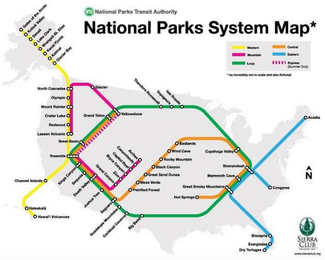
In order to help navigate the Parks, the Sierra Club has designed a System Map based on the urban subway template. This seemingly humorous rendering actually gives travelers a valuable guide in planning their vacations and in connecting the dots between regional marvels.
 |
| Source: Fast Company |
 |
| Source: David Hockney |
